
We moved from Arvada CO to Tucson AZ in 2021. An archive of the Colorado station is here. This page describes the current station in AZ.


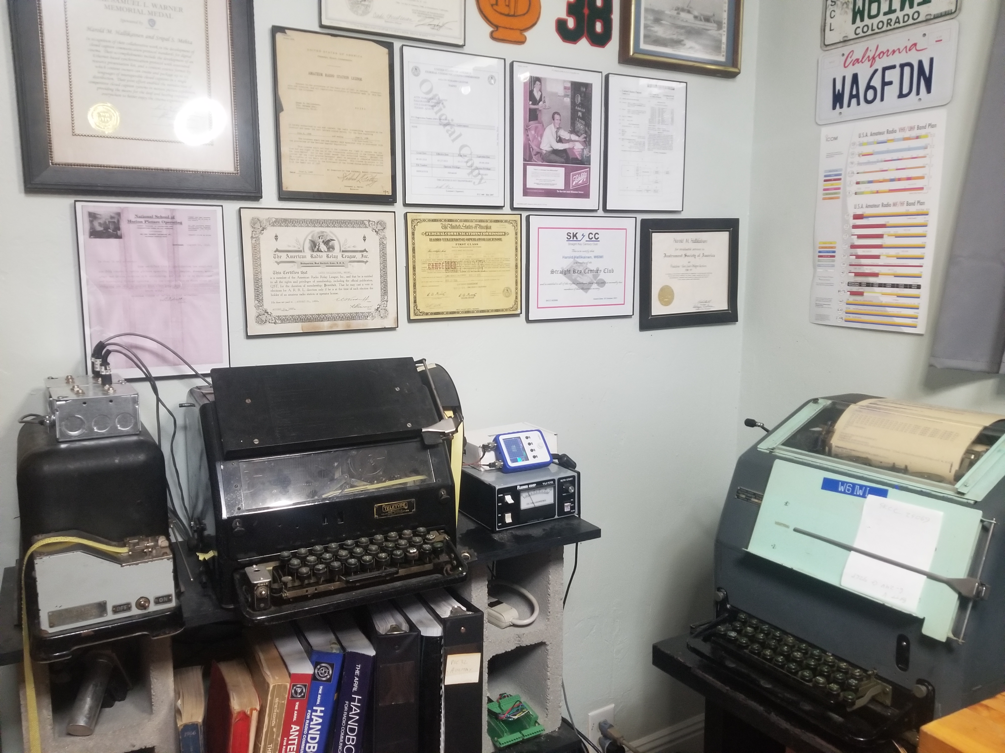
The call letters W6IWI were first used by Kauko Hallikainen in the 1930s (1933 license, 1937 ARRL membership). See the 1934, 1936, 1937, and 1938 Amateur Radio Callbook. The 1930s QSL card was similar to that shown above (I may still have one of the originals somewhere). By 1952, the call had been reassigned to Carson Donaldson in Inglewood CA. He held it through 1977. I acquired the call in 2016. Prior to that, I held the call WA6FDN, and prior to that, WN6FDN. The WA6FDN license was first granted in 1969, with WN6FDN in 1968. WA6FDN shows up in the Summer 1969 Callbook. In December 1969, I took the exam for the First Class Radiotelephone License with Radar Endorsement at the FCC office in San Francisco. That license was later replaced by the FCC with the General Radiotelephone Operator's License. NL7XM offers a great service. He has over 100 years of Radio Amateur Callbooks and will find the first appearance of your callsign in the Callbook. For a reasonable cost, he'll provide certified copies of these pages verifying that the callsign was held by the particular person on this date. This is what he sent me for WN6FDN and WA6FDN.
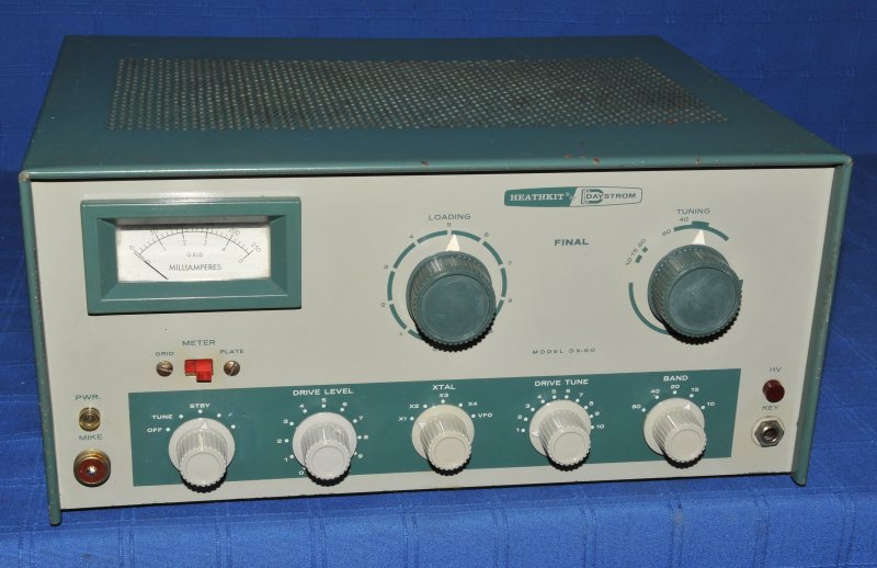
WN6FDN started with a Heathkit DX-60 transmitter and a National NC-300 receiver running CW on HF. WA6FDN used a Viking Ranger transmitter running AM, CW, and RTTY on HF. RTTY used a Teletype model 15 printer (also see a slow motion video of a model 15 in operationg), and a model 14 typing reperf and transmitter distributor. W6IWI now uses an SEA 245 with a Dentron Clipperton-L amplifier running RTTY, CW and SSB into a Zero Five 30 Foot Flagpole Antenna. VHF and UHF FM are covered with a Baofeng UV-5R and a Wouxun KG-UV-6X. The Wouxun KG-UV-6X normally drives a Diamond X50A vertical antenna at home. Mobile info is here.
As shown in the block diagram below,the vintage equipment is back! Click here to see the current Viking Ranger and NC-300!
The table below shows recent contacts logged on qrz.com.
The table below is generated by a PHP script that pulls JSON data from the Reverse Beacon Network, parses it, calculates distance and bearing based on latitude and longitude, then shows data for the last 100 spots. Frequency changes greater than 1 kHz or time changes greater than 1 hour are shown in bold. The Rx links link to the QRZ page for the station. The SNR links link to a graph of signal to noise ratio versus time for that receiver, mode (CW or RTTY), and band (data limited to 100 spots from RBN)
The background color is green if the distance is greater than 3,000 miles. The Relative Distance column has a * for every 200 miles.
| Time | Rx | Freq (kHz) | SNR | Mode | Speed | Rx Location | Distance and Bearing | Relative Distance |
|---|---|---|---|---|---|---|---|---|
| 2008z 31 Jul | AC0C-1 | 14083.88 | 31 dB | RTTY | 45 bps | Louisburg, KS | 1632 km (1014 miles) at 59.6 degrees | ***** |
| 1959z 30 Jul | AC0C-1 | 14083.87 | 36 dB | RTTY | 45 bps | Louisburg, KS | 1632 km (1014 miles) at 59.6 degrees | ***** |
| 2128z 26 Jul | AC0C-1 | 14083.87 | 29 dB | RTTY | 45 bps | Louisburg, KS | 1632 km (1014 miles) at 59.6 degrees | ***** |
| 2144z 24 Jul | AC0C-1 | 14083.88 | 33 dB | RTTY | 45 bps | Louisburg, KS | 1632 km (1014 miles) at 59.6 degrees | ***** |
| 2223z 23 Jul | AC0C-1 | 14083.87 | 41 dB | RTTY | 45 bps | Louisburg, KS | 1632 km (1014 miles) at 59.6 degrees | ***** |
| 2319z 22 Jul | AA4PA | 14083.90 | 21 dB | RTTY | 45 bps | Adamsville, TN | 2116 km (1315 miles) at 75 degrees | ****** |
| 0410z 21 Jul | N2YCH | 14083.90 | 26 dB | RTTY | 45 bps | Trumbull, CT | 3472 km (2157 miles) at 62.3 degrees | ********** |
| 0410z 21 Jul | K9LC | 14083.90 | 18 dB | RTTY | 45 bps | Rockford, IL | 2227 km (1384 miles) at 53.7 degrees | ****** |
| 0358z 21 Jul | NG7M | 7060.0 | 30 dB | CW | 16 wpm | Syracuse, UT | 987 km (613 miles) at 354.3 degrees | *** |
| 0357z 21 Jul | VE4DRK | 7059.9 | 12 dB | CW | 15 wpm | WINNIPEG, MB | 2268 km (1409 miles) at 26.2 degrees | ******* |
| 0344z 21 Jul | KW7MM | 7060.0 | 25 dB | CW | 15 wpm | Chandler, AZ | 32 km (20 miles) at 345.6 degrees | |
| 0344z 21 Jul | KG6NFJ | 7060.0 | 13 dB | CW | 15 wpm | Centerville, OH | 2533 km (1574 miles) at 63.5 degrees | ******* |
| 0342z 21 Jul | W6YX | 7060.0 | 41 dB | CW | 12 wpm | Stanford, CA | 1182 km (734 miles) at 302.2 degrees | *** |
| 0342z 21 Jul | WT8P | 7060.0 | 21 dB | CW | 13 wpm | Sammamish, WA | 1948 km (1210 miles) at 334.3 degrees | ****** |
| 0342z 21 Jul | K3GMQ | 7060.0 | 19 dB | CW | 12 wpm | DOYLESTOWN, PA | 3310 km (2056 miles) at 64 degrees | ********** |
| 0342z 21 Jul | VE6WZ | 7060.0 | 26 dB | CW | 13 wpm | Calgary, AB | 2196 km (1364 miles) at 353.4 degrees | ****** |
| 0342z 21 Jul | VE6WZ | 7060.0 | 31 dB | CW | 13 wpm | Calgary, AB | 2196 km (1364 miles) at 353.4 degrees | ****** |
| 0342z 21 Jul | N6TV | 7060.0 | 32 dB | CW | 13 wpm | San Jose, CA | 1141 km (708 miles) at 302.1 degrees | *** |
| 0342z 21 Jul | K7RUT | 7060.0 | 18 dB | CW | 12 wpm | Anderson Island, WA | 1941 km (1206 miles) at 332.3 degrees | ****** |
| 0342z 21 Jul | K9IMM | 7060.0 | 24 dB | CW | 13 wpm | Mount Horeb, WI | 2194 km (1363 miles) at 51.3 degrees | ****** |
| 0342z 21 Jul | NG7M | 7060.0 | 30 dB | CW | 13 wpm | Syracuse, UT | 987 km (613 miles) at 354.3 degrees | *** |
| 0342z 21 Jul | WA7LNW | 7060.0 | 41 dB | CW | 13 wpm | Washington, UT | 595 km (369 miles) at 337.3 degrees | * |
| 0342z 21 Jul | AK6RI-1 | 7060.0 | 28 dB | CW | 12 wpm | Sunnyvale, CA | 1166 km (725 miles) at 302.3 degrees | *** |
| 0342z 21 Jul | TI7W | 7060.0 | 24 dB | CW | 13 wpm | Guanacaste, Costa Rica | 3566 km (2216 miles) at 126.3 degrees | *********** |
| 0342z 21 Jul | VE6WZ-3 | 7060.0 | 31 dB | CW | 13 wpm | Calgary, AB | 2196 km (1364 miles) at 353.4 degrees | ****** |
| 0342z 21 Jul | WB6BEE | 7060.0 | 23 dB | CW | 13 wpm | Williamsburg, VA | 3065 km (1905 miles) at 69 degrees | ********* |
| 0342z 21 Jul | K6FOD | 7060.0 | 30 dB | CW | 13 wpm | South Pasadena, CA | 706 km (438 miles) at 289.1 degrees | ** |
| 0342z 21 Jul | NU4F | 7060.0 | 13 dB | CW | 13 wpm | Fort Lauderdale, FL | 3049 km (1894 miles) at 94.8 degrees | ********* |
| 0342z 21 Jul | W4KAZ | 7060.0 | 21 dB | CW | 12 wpm | Cary, NC | 2969 km (1845 miles) at 73.5 degrees | ********* |
| 0342z 21 Jul | LU8XW | 7060.0 | 13 dB | CW | 13 wpm | TIERRA DEL FUEGO, Argentina | 10497 km (6523 miles) at 157 degrees | ******************************** |
| 0342z 21 Jul | N2CR | 7060.0 | 13 dB | CW | 13 wpm | Morris Plains, NJ | 3364 km (2090 miles) at 63 degrees | ********** |
| 0342z 21 Jul | N7VVX | 7060.0 | 17 dB | CW | 12 wpm | Centerville, UT | 971 km (603 miles) at 355 degrees | *** |
| 0342z 21 Jul | W3DAN | 7060.0 | 22 dB | CW | 14 wpm | West Middlesex, PA | 2775 km (1724 miles) at 60.5 degrees | ******** |
| 0424z 18 Jul | PY2KNK | 14083.90 | 23 dB | RTTY | 45 bps | São Paulo, Brazil | 9051 km (5624 miles) at 125.1 degrees | **************************** |
| 0344z 18 Jul | K1RA-4 | 7060.0 | 18 dB | CW | 16 wpm | Warrenton, VA | 3063 km (1903 miles) at 67 degrees | ********* |
| 0344z 18 Jul | PI4CC | 7060.0 | 11 dB | CW | 16 wpm | Netherlands | 8724 km (5420 miles) at 34.7 degrees | *************************** |
| 0344z 18 Jul | N2EPE | 7060.0 | 19 dB | CW | 15 wpm | Pittsford, NY | 3145 km (1954 miles) at 57.9 degrees | ********* |
| 0344z 18 Jul | WE9V | 7060.0 | 21 dB | CW | 16 wpm | Bristol, WI | 2309 km (1435 miles) at 53.7 degrees | ******* |
| 0344z 18 Jul | N7TUG | 7060.0 | 7 dB | CW | 16 wpm | Seattle, WA | 1973 km (1226 miles) at 333.9 degrees | ****** |
| 0343z 18 Jul | N9CO | 7060.0 | 21 dB | CW | 15 wpm | Sycamore, IL | 2242 km (1393 miles) at 54.7 degrees | ****** |
| 0342z 18 Jul | WT8P | 7060.0 | 22 dB | CW | 12 wpm | Sammamish, WA | 1948 km (1210 miles) at 334.3 degrees | ****** |
| 0342z 18 Jul | KM3T-5 | 7060.0 | 21 dB | CW | 13 wpm | Amherst, NH | 3617 km (2248 miles) at 59.6 degrees | *********** |
| 0342z 18 Jul | WB6BEE | 7060.0 | 24 dB | CW | 12 wpm | Williamsburg, VA | 3065 km (1905 miles) at 69 degrees | ********* |
| 0342z 18 Jul | W3DAN | 7060.0 | 21 dB | CW | 12 wpm | West Middlesex, PA | 2775 km (1724 miles) at 60.5 degrees | ******** |
| 0342z 18 Jul | AK6RI-1 | 7060.0 | 28 dB | CW | 13 wpm | Sunnyvale, CA | 1166 km (725 miles) at 302.3 degrees | *** |
| 0342z 18 Jul | N7VVX | 7060.0 | 21 dB | CW | 12 wpm | Centerville, UT | 971 km (603 miles) at 355 degrees | *** |
| 0342z 18 Jul | KM3T-2 | 7060.0 | 17 dB | CW | 12 wpm | Amherst, NH | 3617 km (2248 miles) at 59.6 degrees | *********** |
| 0342z 18 Jul | TI7W | 7060.0 | 24 dB | CW | 13 wpm | Guanacaste, Costa Rica | 3566 km (2216 miles) at 126.3 degrees | *********** |
| 0342z 18 Jul | K9IMM | 7060.0 | 24 dB | CW | 13 wpm | Mount Horeb, WI | 2194 km (1363 miles) at 51.3 degrees | ****** |
| 0342z 18 Jul | K3PA-1 | 7060.0 | 29 dB | CW | 13 wpm | Tonganoxie, KS | 1626 km (1010 miles) at 57.4 degrees | ***** |
| 0342z 18 Jul | W8WTS | 7060.0 | 20 dB | CW | 12 wpm | Chagrin Falls, OH | 2813 km (1747 miles) at 60.3 degrees | ******** |
| 0342z 18 Jul | KW7MM-2 | 7060.0 | 25 dB | CW | 12 wpm | Chandler, AZ | 32 km (20 miles) at 345.6 degrees | |
| 0342z 18 Jul | NG7M | 7060.0 | 24 dB | CW | 12 wpm | Syracuse, UT | 987 km (613 miles) at 354.3 degrees | *** |
| 0342z 18 Jul | AC0C-1 | 7060.0 | 30 dB | CW | 12 wpm | Louisburg, KS | 1632 km (1014 miles) at 59.6 degrees | ***** |
| 0342z 18 Jul | W8WWV | 7060.0 | 19 dB | CW | 12 wpm | Chesterland, OH | 2802 km (1741 miles) at 60 degrees | ******** |
| 0342z 18 Jul | W6YX | 7060.0 | 37 dB | CW | 13 wpm | Stanford, CA | 1182 km (734 miles) at 302.2 degrees | *** |
| 0342z 18 Jul | N2CR | 7060.0 | 12 dB | CW | 13 wpm | Morris Plains, NJ | 3364 km (2090 miles) at 63 degrees | ********** |
| 0342z 18 Jul | WA7LNW | 7060.0 | 20 dB | CW | 13 wpm | Washington, UT | 595 km (369 miles) at 337.3 degrees | * |
| 0342z 18 Jul | VE6WZ | 7060.0 | 23 dB | CW | 13 wpm | Calgary, AB | 2196 km (1364 miles) at 353.4 degrees | ****** |
| 0342z 18 Jul | N6TV | 7060.0 | 30 dB | CW | 13 wpm | San Jose, CA | 1141 km (708 miles) at 302.1 degrees | *** |
| 0342z 18 Jul | N4HAC | 7060.0 | 18 dB | CW | 13 wpm | Hume, VA | 3041 km (1890 miles) at 66.8 degrees | ********* |
| 0342z 18 Jul | K5TR | 7060.0 | 32 dB | CW | 13 wpm | Austin, TX | 1215 km (755 miles) at 97.2 degrees | *** |
| 0342z 18 Jul | CX6VM | 7060.0 | 23 dB | CW | 12 wpm | Cerro Largo, Uruguay | 9317 km (5789 miles) at 134.5 degrees | **************************** |
| 0342z 18 Jul | ND7K | 7060.0 | 31 dB | CW | 12 wpm | Wickenburg, AZ | 270 km (168 miles) at 319.2 degrees | |
| 0342z 18 Jul | KM3T-3 | 7060.0 | 20 dB | CW | 13 wpm | Amherst, NH | 3617 km (2248 miles) at 59.6 degrees | *********** |
| 0342z 18 Jul | W2NNN | 7060.0 | 18 dB | CW | 13 wpm | Bridgewater, NJ | 3355 km (2085 miles) at 63.3 degrees | ********** |
| 0342z 18 Jul | KW7MM | 7060.0 | 24 dB | CW | 13 wpm | Chandler, AZ | 32 km (20 miles) at 345.6 degrees | |
| 0342z 18 Jul | K6FOD | 7060.0 | 28 dB | CW | 12 wpm | South Pasadena, CA | 706 km (438 miles) at 289.1 degrees | ** |
| 0342z 18 Jul | WT9U | 7060.0 | 18 dB | CW | 13 wpm | ELKHART, IN | 2435 km (1513 miles) at 57.6 degrees | ******* |
| 0342z 18 Jul | W3RGA | 7060.0 | 20 dB | CW | 13 wpm | Sunbury, PA | 3176 km (1973 miles) at 62.6 degrees | ********* |
| 2230z 17 Jul | AC0C-1 | 14083.88 | 45 dB | RTTY | 45 bps | Louisburg, KS | 1632 km (1014 miles) at 59.6 degrees | ***** |
| 0159z 17 Jul | N2YCH | 14083.90 | 20 dB | RTTY | 45 bps | Trumbull, CT | 3472 km (2157 miles) at 62.3 degrees | ********** |
| 0159z 17 Jul | AC0C-1 | 14083.87 | 30 dB | RTTY | 45 bps | Louisburg, KS | 1632 km (1014 miles) at 59.6 degrees | ***** |
| 0027z 17 Jul | K9LC | 14083.90 | 17 dB | RTTY | 45 bps | Rockford, IL | 2227 km (1384 miles) at 53.7 degrees | ****** |
| 0027z 17 Jul | AC0C-1 | 14083.87 | 25 dB | RTTY | 45 bps | Louisburg, KS | 1632 km (1014 miles) at 59.6 degrees | ***** |
| 0443z 16 Jul | N2YCH | 14083.90 | 20 dB | RTTY | 45 bps | Trumbull, CT | 3472 km (2157 miles) at 62.3 degrees | ********** |
| 0443z 16 Jul | KH6LC | 14083.86 | 20 dB | RTTY | 45 bps | Keaau, HI | 4652 km (2891 miles) at 264.3 degrees | ************** |
| 2240z 13 Jul | N2YCH | 14083.90 | 15 dB | RTTY | 45 bps | Trumbull, CT | 3472 km (2157 miles) at 62.3 degrees | ********** |
| 0410z 12 Jul | K9LC | 14083.80 | 32 dB | RTTY | 45 bps | Rockford, IL | 2227 km (1384 miles) at 53.7 degrees | ****** |
| 0402z 12 Jul | KW7MM | 7060.0 | 23 dB | CW | 12 wpm | Chandler, AZ | 32 km (20 miles) at 345.6 degrees | |
| 0402z 12 Jul | VE4DRK | 7059.9 | 11 dB | CW | 12 wpm | WINNIPEG, MB | 2268 km (1409 miles) at 26.2 degrees | ******* |
| 0402z 12 Jul | K1RA-4 | 7060.0 | 14 dB | CW | 12 wpm | Warrenton, VA | 3063 km (1903 miles) at 67 degrees | ********* |
| 0402z 12 Jul | WT8P | 7060.0 | 19 dB | CW | 13 wpm | Sammamish, WA | 1948 km (1210 miles) at 334.3 degrees | ****** |
| 0402z 12 Jul | VE6WZ-3 | 7060.0 | 34 dB | CW | 13 wpm | Calgary, AB | 2196 km (1364 miles) at 353.4 degrees | ****** |
| 0402z 12 Jul | AK6RI-1 | 7060.0 | 26 dB | CW | 13 wpm | Sunnyvale, CA | 1166 km (725 miles) at 302.3 degrees | *** |
| 0402z 12 Jul | WE9V | 7060.0 | 26 dB | CW | 13 wpm | Bristol, WI | 2309 km (1435 miles) at 53.7 degrees | ******* |
| 0402z 12 Jul | W6YX | 7060.0 | 35 dB | CW | 13 wpm | Stanford, CA | 1182 km (734 miles) at 302.2 degrees | *** |
| 0402z 12 Jul | WA7LNW | 7060.0 | 31 dB | CW | 13 wpm | Washington, UT | 595 km (369 miles) at 337.3 degrees | * |
| 0402z 12 Jul | W1NT-6 | 7060.0 | 22 dB | CW | 13 wpm | Newton, NH | 3665 km (2277 miles) at 59.6 degrees | *********** |
| 0402z 12 Jul | WB6BEE | 7060.0 | 22 dB | CW | 12 wpm | Williamsburg, VA | 3065 km (1905 miles) at 69 degrees | ********* |
| 0402z 12 Jul | K5EM | 7060.0 | 27 dB | CW | 13 wpm | Seattle, WA | 1969 km (1224 miles) at 334 degrees | ****** |
| 0402z 12 Jul | KM3T-5 | 7060.0 | 22 dB | CW | 12 wpm | Amherst, NH | 3617 km (2248 miles) at 59.6 degrees | *********** |
| 0402z 12 Jul | VE6WZ | 7060.0 | 34 dB | CW | 13 wpm | Calgary, AB | 2196 km (1364 miles) at 353.4 degrees | ****** |
| 0402z 12 Jul | VE6WZ | 7060.0 | 31 dB | CW | 13 wpm | Calgary, AB | 2196 km (1364 miles) at 353.4 degrees | ****** |
| 0402z 12 Jul | AC0C-1 | 7060.0 | 35 dB | CW | 13 wpm | Louisburg, KS | 1632 km (1014 miles) at 59.6 degrees | ***** |
| 0402z 12 Jul | N9CO | 7060.0 | 26 dB | CW | 13 wpm | Sycamore, IL | 2242 km (1393 miles) at 54.7 degrees | ****** |
| 0402z 12 Jul | K9IMM | 7060.0 | 32 dB | CW | 13 wpm | Mount Horeb, WI | 2194 km (1363 miles) at 51.3 degrees | ****** |
| 0402z 12 Jul | N7VVX | 7060.0 | 15 dB | CW | 12 wpm | Centerville, UT | 971 km (603 miles) at 355 degrees | *** |
| 0402z 12 Jul | W1NT-2 | 7060.0 | 23 dB | CW | 13 wpm | Newton, NH | 3665 km (2277 miles) at 59.6 degrees | *********** |
| 0402z 12 Jul | W2NNN | 7060.0 | 20 dB | CW | 13 wpm | Bridgewater, NJ | 3355 km (2085 miles) at 63.3 degrees | ********** |
The plot below shows a historic plot of W6IWI HF CW and RTTY activity.
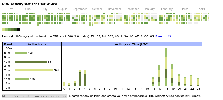
Also see here for a graphical representation of all RBN data. There is also a
new version under development that shows similar graphs but also paths between
transmit and receive sites on a map.
NOTE: RBN only reports CQ or TEST. It does not report every QSO. Send one of the following (I use CW and RTTY) to generate RBN spots:
You can also use the form below to get a more detailed RBN report.
Here's a set of graphs of CW speeds on RBN.
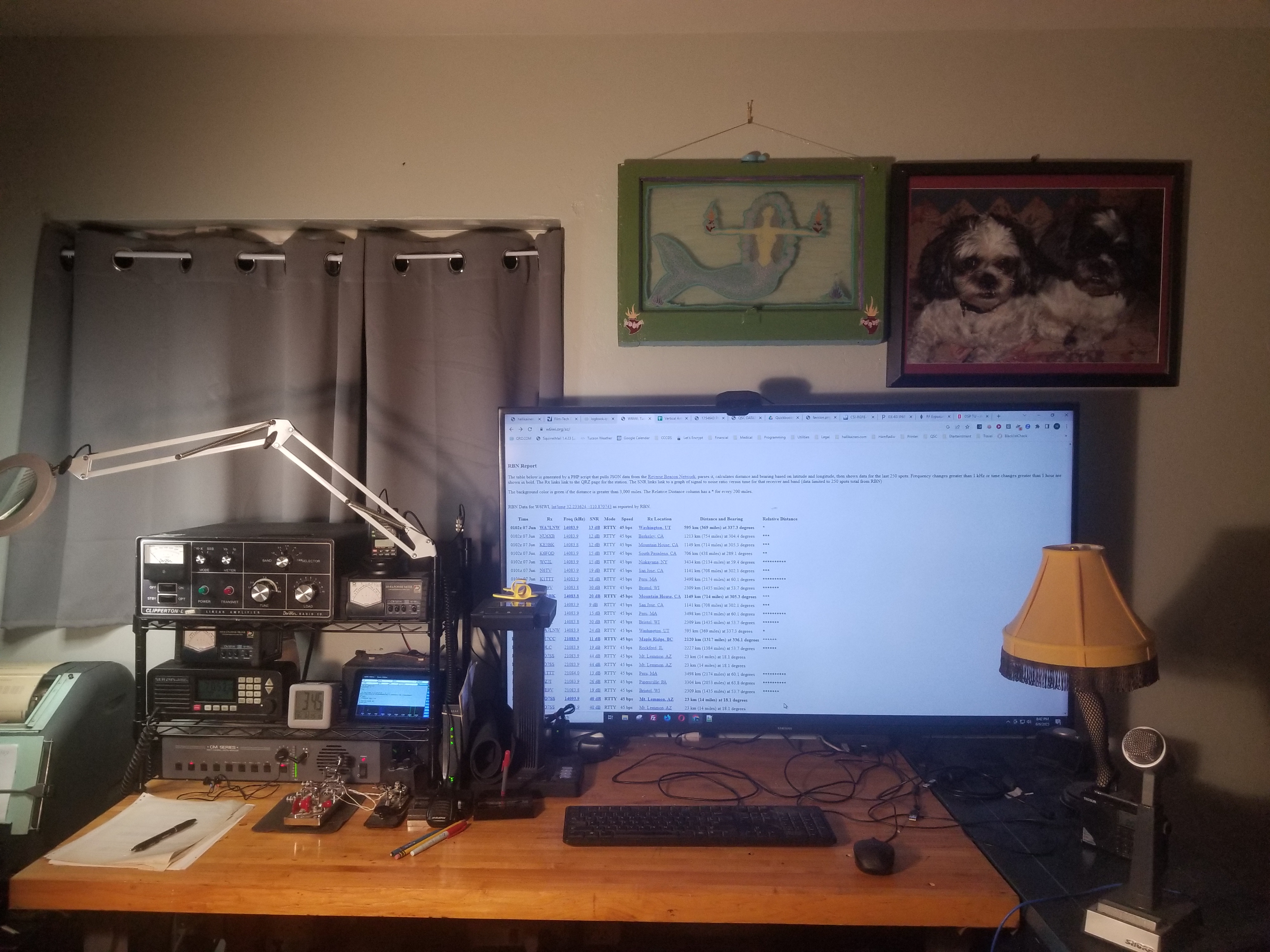
Operating PositionThe image at the right shows the operating position. Left to right, the following items are visible.
|  |
RTTY CornerFor more on RTTY, see here.
|
 |
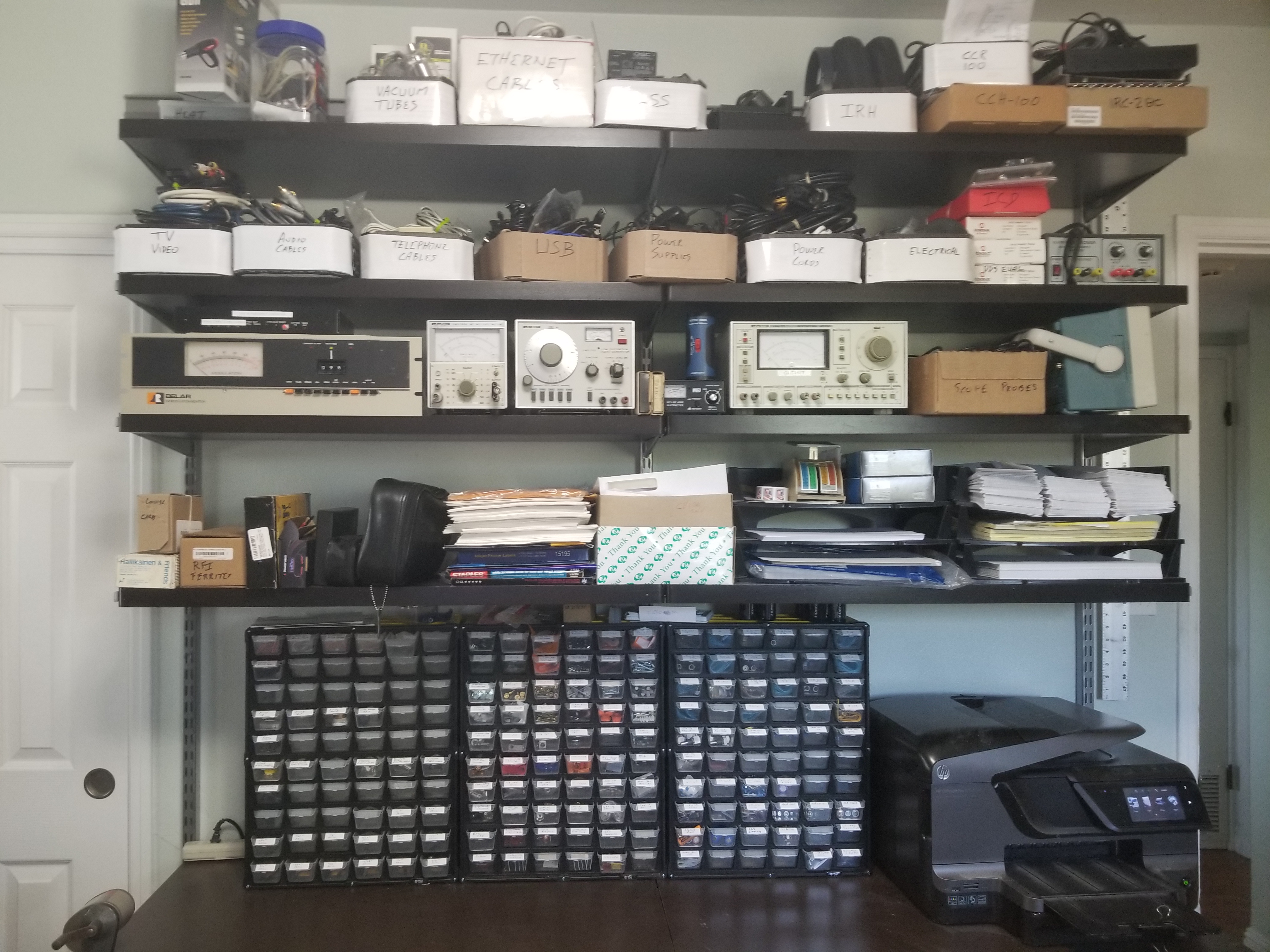
Test Equipment and Parts!Piles of stuff! Test equipment includes a digital oscilloscope, audio generator, audio THD analyser, audio voltmeter, FM modulation monitor (Belar FMM-2), antenna analyzer, regulated variable DC power supply, USB-based logic analyzer, etc. Below the desktop there are boxes of manuals to be scanned for Saving History From The Dumpster. |
 |
More Stuff!Shelves with more supplies, equipment I designed, a Houston Instrument DMP-29 plotter, Ampex reel to reel tape recorder, and a Webcor wire recorder. | 
|
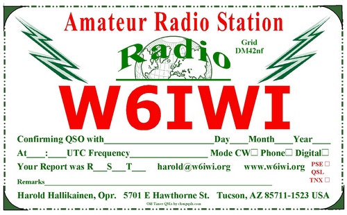
I will always send a QSL card on receiving one. Recently received QSL cards are here.
Calculations on RF Safety are located here.